
If you’ve been keeping an ear on the weather news lately, you might have caught some of the buzz about El Niño gearing up for a serious comeback in 2026. This isn’t just another seasonal blip. Meteorologists have been sounding the alarm over a massive plume of warm water barreling across the Pacific Ocean like a freight train, and the forecasts are painting a picture of something potentially very strong – maybe even one of the strongest on record.
As the team over here at Mold Only who spends our days helping folks battle moisture and black mold exposure, we thought it was worth breaking this down in detail. After all, what happens out there in the ocean often ends up affecting the air inside our South Florida homes.
The latest on this developing El Niño
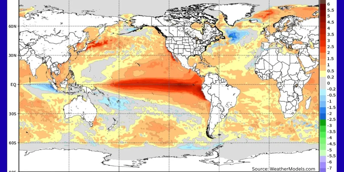
As of mid-2026, things are heating up fast in the equatorial Pacific. A big subsurface plume of unusually warm water is on the move, described by forecasters as chugging along like a freight train. Meteorologist Ben Noll highlighted this recently, noting record-breaking warmth in spots peaking around 7°C (that’s over 13°F) above average. Models from places like the ECMWF are showing this new plume could push temperatures up by +3°C in many scenarios by November, which would put the event among the strongest El Niños we’ve seen.
Ryan Maue, another well-known meteorologist, called the updated forecast for this summer and autumn “off the charts” extreme. He’s talking about boiling red colors on the temperature maps across the central and eastern Pacific – basically code red for the climate system heading into the rest of 2026. NOAA is backing this up with high confidence too: around an 82% chance El Niño develops between May and July, and a 96% chance it sticks around through the winter of 2026-27. Some outlooks are even whispering about a super El Niño.
For those who might not follow this stuff closely, El Niño is that pattern where sea surface temperatures in the central and eastern Pacific run warmer than normal. It throws off the usual wind patterns, strengthens the Pacific jet stream, and ends up rearranging rainfall, temperatures, and storm tracks all over the globe. When it’s strong, the effects can be pretty noticeable.
How this could play out for South Florida weather
Let’s start with the hurricane side of things, since that’s always top of mind around here. The silver lining with a strong El Niño is that it usually ramps up wind shear across the Atlantic. That shear acts like a pair of scissors, chopping up developing tropical systems before they can really get going. We could be looking at a quieter than average hurricane season overall – fewer named storms and a lower chance of big ones making a direct hit. That’s welcome news after some of the active years we’ve had. But remember, it doesn’t mean zero risk. Warm waters in the Gulf and Atlantic can still cook up something serious if everything lines up just right. Keep those emergency kits ready and don’t let your guard down completely.
Moving into summer and fall, expect the pattern to bring more moisture around at times. We’re already seeing some relief from drought conditions in parts of the state with heavier thunderstorm activity possible. More clouds and rain can help keep temperatures a bit more moderate too, which might feel like a small break from the usual brutal heat and humidity.
The bigger shift for us often shows up in the winter and early spring – our traditional dry season. A stronger El Niño tends to push the southern branch of the jet stream more active, steering extra storms and moisture straight into the southern United States, including the Gulf Coast and Florida. That can mean above-average rainfall when we usually count on drier weather. Past strong events have brought 30-50% more rain in spots across the peninsula. Think greener landscapes, but also more gray skies, higher chances of flooding in low-lying areas, and humidity that sticks around longer than we’d like.
One thing that comes with all that extra storminess is an uptick in severe weather potential during the cooler months. Central and South Florida can see more strong thunderstorms and even an increased risk of tornadoes when winter fronts roll through. It’s not the same as our summer afternoon pop-ups – these can be fast-moving and pack a serious punch.
Why this matters for mold and your home
This is the part where we at Mold Only pay extra close attention. South Florida already fights a constant battle with humidity and moisture. Layer on a strong El Niño with its wetter tendencies, and you’ve got conditions that can really encourage mold growth if you’re not careful.
Extra rainfall means more saturated ground, higher water tables, and greater chances for water to find its way into places it shouldn’t – through foundations, around windows, or up through slabs in flood-prone spots. That prolonged humidity, especially if it lingers into our drier months, keeps indoor moisture levels elevated. Attics, crawl spaces, bathrooms, and walls become prime real estate for hidden mold. We’ve seen it time and again after wet seasons: families dealing with musty smells, allergy flare-ups, or worse, structural issues that could have been caught earlier.
A super El Niño could amplify all of this. More intense rain events, potential flooding, and extended muggy periods mean dehumidifiers and proper ventilation have to work overtime. If you’ve had past water intrusion problems or live in an older home, this is the kind of season where small leaks can turn into bigger headaches fast.
What you can do to stay ahead of it
Nobody likes feeling helpless when the weather throws curveballs, so here are some practical steps worth taking:
- Walk around your property now and check roofs, gutters, downspouts, and grading around the foundation. Make sure water has a clear path away from the house.
- Service your AC unit and consider adding or checking a whole-home dehumidifier – these are lifesavers in keeping indoor humidity in check.
- If you notice any damp spots, musty odors, or have had mold issues before, get a professional inspection sooner rather than later. Catching moisture early saves money and stress.
- Stay plugged into reliable forecasts from the National Weather Service. While big-picture patterns like El Niño give us clues, day-to-day and week-to-week details still matter.
- In flood-prone areas, think about simple improvements like sump pumps or barriers if it makes sense for your situation.
We’re not climate scientists or meteorologists at Mold Only – we’re just local folks who see the real-world results of wet weather week in and week out. A strong El Niño doesn’t have to spell disaster, but it does call for being a bit more proactive about protecting your home and family from excess moisture.
If things start feeling damp or you spot any signs of mold as this pattern develops, don’t wait it out. Reach out to us and we’ll help sort it properly. Early action really does make all the difference. South Florida has dealt with plenty of wild weather over the years, and we’ll get through this one too. Stay informed, stay prepared, and keep your home as dry as possible. We’ll be keeping an eye on how this El Niño freight train unfolds and sharing updates as we go.
El Niño has a well-documented, often dramatic influence on global hurricane seasons, acting like a seesaw between ocean basins. It tends to crank up activity in the central and eastern Pacific while putting the brakes on the Atlantic. This pattern stems from shifts in sea surface temperatures, atmospheric circulation, and wind patterns that ripple across the tropics.
Why El Niño suppresses Atlantic hurricanes
The primary culprit is increased vertical wind shear over the tropical Atlantic. Vertical wind shear is the change in wind speed and direction with height in the atmosphere. Hurricanes need a relatively stable vertical structure to organize and intensify—think of them as needing a tall, upright “chimney” of rising warm, moist air.
During El Niño, warmer waters in the central and eastern Pacific fuel more thunderstorms and rising air there. This alters the Walker Circulation: it strengthens upper-level westerly winds that blow across the Atlantic. Combined with stronger low-level easterly trade winds, this creates hostile shear that “tears the tops off” developing tropical disturbances before they can become full-fledged storms.
Additional factors include:
- More sinking air (subsidence) over the Atlantic, which dries out the atmosphere.
- Increased atmospheric stability, making it harder for air parcels to rise vigorously.
These conditions typically peak during the heart of Atlantic hurricane season (August–October).
El Niño’s Boost to Pacific hurricanes
In contrast, El Niño reduces wind shear and enhances conditions in the central and eastern Pacific. Warmer waters expand the area where storms can thrive, often leading to more frequent and intense Pacific hurricanes. Some can even threaten Hawaii or, rarely, influence the U.S. West Coast as tropical remnants.
Historical patterns and statistics
Data backs this up clearly:
- Atlantic activity drops noticeably in El Niño years. Strong or “super” El Niños tend to produce the quietest seasons. For example, in comparable strong El Niño years since 1990, averages hovered around 11 named storms, 4 hurricanes, and 2 major hurricanes—well below long-term norms of about 14 named storms, 7 hurricanes, and 3 majors.
- U.S. landfalls decrease. Studies show roughly half the chance of multiple U.S. hurricane landfalls during El Niño compared to neutral or La Niña years. Major hurricane landfalls are especially rare.
- Strong El Niño examples (like 1982, 1997, 2015) were notably quiet in the Atlantic, though not completely storm-free.
La Niña does the opposite: lower shear, more rising air, and often hyperactive Atlantic seasons with higher landfall risks.
Nuances and caveats — It’s not a total shutdown
Even in strong El Niño years, the Atlantic isn’t guaranteed to be dead quiet:
- Individual storms that do form can sometimes intensify rapidly if they avoid high shear zones (e.g., closer to the U.S. coast or in the Gulf).
- Steering patterns may shift; a weaker Bermuda High during some El Niños can influence tracks, sometimes keeping storms farther from the U.S. East Coast but not always.
- Other factors like Atlantic sea surface temperatures (often warmer in recent decades) and the Madden-Julian Oscillation can still allow outbreaks of activity.
- It only takes one major hurricane to make it a bad season for affected communities.
Looking at The 2026 El Niño Season
With a potentially strong or super El Niño developing (high confidence of formation this summer and persistence through winter), forecasters like NOAA, Colorado State University, and others are calling for a below-average 2026 Atlantic hurricane season. Early outlooks suggest fewer named storms, hurricanes, and majors than the long-term average.
This could mean good news for reduced overall risk in places like South Florida, but experts universally caution against complacency. Warm Atlantic waters and the unpredictability of any single storm keep the need for preparation high.
Planning for a Super El Niño Season in South Florida
El Niño is one of the strongest natural modulators of seasonal hurricane activity. Its suppressive effect on the Atlantic comes through reliable physical mechanisms, backed by decades of observations. Yet tropical weather always carries uncertainty—patterns set the odds, but they don’t eliminate the game. Coastal residents, especially in the Gulf and Atlantic states, should treat every season seriously regardless of the headline forecast.
If you’re in a vulnerable area, focus on your personal preparedness plan: evacuation routes, supplies, insurance reviews, and home hardening. The science is clear on the broader impacts, but smart local action is what truly makes the difference. South Florida residents should expect a below-average hurricane season, however, there may be quite a bit of rainfall, and with that comes water damage and mold. If your home gets hit with heavy rain and you spot black spots or smell a musty oder, you likely have mold growing. And, if that happens, you may require expert mold removal and remediation services to get rid of it safely and effectively.
In any event, feel free to contact us online, or get a free mold removal estimate from our team.